
Blog

Why GNSS Land Levellers Are Better Than Traditional Land Levelling
Picture this. You spend a full morning levelling a field the old way, you're sweaty, the diesel's nearly gone, and you still end up with one corner that floods every single time you irrigate. Maddening, right? That exact headache is why a GNSS Land Leveller has quietly become the thing every serious farmer keeps asking about. It's not a fancy upgrade for show. It actually fixes the problem at the root.
So let's talk about why the satellite guided way beats the old guesswork, in plain terms, with no jargon dump.
What Traditional Land Levelling Really Costs You
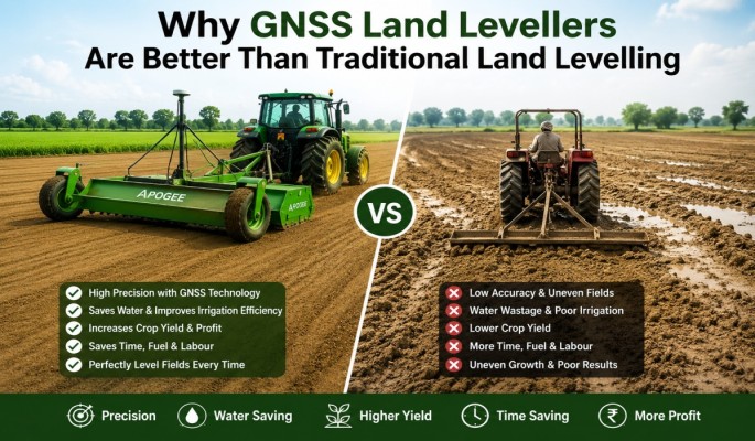
Old style levelling sounds simple. Drag a blade, smooth the surface, done.
But it never quite is.
You rely on the operator's eyes and instinct. And honestly, even a brilliant tractor driver can't read the slope of a whole field by looking at it. Small dips slip through. Tiny high spots stay hidden. Then water shows up and exposes every mistake at once.
The bigger cost is the stuff you don't see right away. Wasted water. Extra passes. Patchy crops. Hours you'll never get back. None of it screams "expensive" in the moment, but it all adds up across a season.
How a GNSS Land Leveller Changes the Game
Here's the short version. The machine talks to satellites, works out the exact height of every patch of your field, and then tells the tractor where to cut soil and where to drop it. By itself. No squinting, no second guessing.
That accuracy sits at the centimetre level. Which sounds like a tiny detail until you realise flat ground fixes about ten problems in one go.
Want the full breakdown of how the tech actually works? This complete walkthrough of precision land preparation lays it out step by step.
Accuracy You Can Actually Trust
A person gets tired. A satellite doesn't.
The system levels the same way on the first pass and the fiftieth. No drop in focus after lunch, no shaky hand near the boundary. You get an even field every time, and even fields are where good harvests start.
Water That Goes Where It Should
Water is precious here. We all know it.
On bumpy land, the high bits stay dry while the low bits turn into ponds. So you overwater, the crop still struggles, and your bill climbs anyway. A levelled field flips that completely. Water spreads, soaks in evenly, and you stop pouring it down the drain.
There's a clear look at how flatter fields trim down water waste if you want the actual reasoning behind it.
Less Time, Less Diesel
Traditional levelling means going over the same ground again and again. Cut, check, fix, check again, until you're frankly done with the whole thing.
A GNSS setup usually wraps the job in one clean run. Fewer passes. Less fuel burned. More of your day back for everything else that's waiting.
Is It Worth the Higher Price Tag?
Fair question. And yes, the upfront cost is more. No point hiding that.
But look at the full picture before you decide:
1. Lower fuel bills because you finish in fewer runs
2. Less water used every single season
3. Higher yields from properly flat ground
4. Less redo work chasing dips and bumps
Stretch that across a few seasons and the machine quietly pays for itself. Plenty of farmers have already done the maths and made the jump, and this look at why they're switching covers the thinking nicely.
Picking What Suits Your Land
Not every farm needs the top shelf model. And that's perfectly fine.
The 2D version handles standard levelling beautifully and suits farmers who want precision without extra complexity. The 3D version maps your whole field as a design and levels to match it, which big farms and serious precision jobs really love.
Still weighing it up? You can browse the full range of satellite levelling systems and match one to your plot size. And if you just want to see how this fits into smarter, modern farming overall, the bigger story is worth a read too. There's also a good piece on how this technology is spreading across farms today.
The Honest Bottom Line
If you farm a tiny patch and have time to burn, the old way can still limp along.
But if you want flat fields, smaller water bills, healthier crops, and your evenings back? The choice gets pretty clear, pretty fast. Better groundwork really does change everything that comes after it.
FAQs
1. What is a GNSS Land Leveller?
It's a satellite guided machine that levels your field to centimetre accuracy, telling the tractor exactly where to cut and fill soil on its own.
2. Why is a GNSS Land Leveller better than traditional levelling?
It removes the guesswork. You get even ground in fewer passes, which means less diesel, less water, and steadier crops.
3. Does it really save water?
Yes, quite a bit. Level fields let water spread evenly, so you stop drowning low spots and starving high ones.
4. Is it a good fit for small farms?
It can be, especially the 2D model. The bigger savings usually show up on medium and large fields though.
5. Is the higher cost actually worth it?
Over a few seasons, yes. Fuel savings, water savings, and better yields tend to cover the upfront price.
.png)


